30 December 2015

Coastal CA, part 2

Hello, San Francisco! We headed into the big city for a couple of hours for some of the usual tourist stuff...drive over the Golden Gate Bridge, and walk at Pier 39 (Fisherman's Wharf). We tried to get tickets to visit Alcatraz, but they were sold out until January 5! So instead we had lunch and walked around a bit.

Stinky sea lion on the pier.

The next day Steve and I went back to Pinnacles NP, the west entrance this time, and Dad and Barb went on a Winchester Mansion tour in San Jose. The tour sounded like it was sort of interesting and definitely unique. The other side of Pinnacles had more caves and a tougher hike, but was otherwise similar to the other side of the park.


This time I brought my tripod and got a couple of pictures in and around the caves. It was cold inside them (ice on the ground) and also cold wherever the sun didn't strike.

On our way back from Pinnacles we took a scenic detour though Carmel Valley, which was a fun, twisty road through the countryside. There were lots of small farms - cattle and vineyards (or, as we call them 'grape orchards'):

As I stepped out of the car to take this picture, Steve said "Make sure you get the drool in the shot". I *think* he was referring to the calf.  The cows were pretty wary of me.

29 December 2015

Coastal CA, part 1, and Happy Birthday Steve!!

After Christmas we met Dad and Barb near Monterey/Santa Cruz for a few nights. We stayed in a KOA camping cabin, which was pretty nice except that it was really cold at night (we had a good heater) and the showers weren't in a heated building! The showers were nice and hot, but getting out and drying off was pretty brutal since it would be in the mid-30s in the mornings.

We spent a day (Steve's Birthday!) exploring the caves and hiking at the east entrance to Pinnacles National Park (USA's newest national park, created in 2013 from what was Pinnacles National Monument). The park is the site of an ancient volcano, and the caves were formed as chunks of mountain broke off and got wedged in tight places. There are California condors in the park, though we don't think we saw any.

The park from above the Bear Gulch reservoir. It would be brutally hot here in the summer!
 Steve and Dad at the dam end of the reservoir.
The reservoir. It seemed like a weird place to build one. There was a little bit of water from the reservoir seeping into the caves below it, making waterfalls in the caves. I didn't bring my tripod so I didn't get any pictures inside the caves.
Woodpeckers peck holes into the trees, and then acorns get stuffed into the holes - but I don't know if it was birds or squirrels putting the nuts in the holes!

We also spent time walking on the beach and playing on the rocks at Point Lobos. We saw dolphins and sea otters and sea lions and lots of birds.

25 December 2015

Christmas in Yosemite

We drove alllllllllllllllllllll day Christmas Eve to get to the Yosemite area...~15 hours total. Fortunately, it was a fairly uneventful drive...a bit of rain in Washington and parts of Oregon, then snow falling but good roads over the southern Oregon mountain passes (didn't need to put chains on the tires), and clouds in N California. We'd booked a hotel room in Mariposa, CA for two nights (a room with a fireplace!) and got in about 8 pm Christmas Eve.  I'm pretty sure this is the first Christmas Eve where I've only eaten fast food.

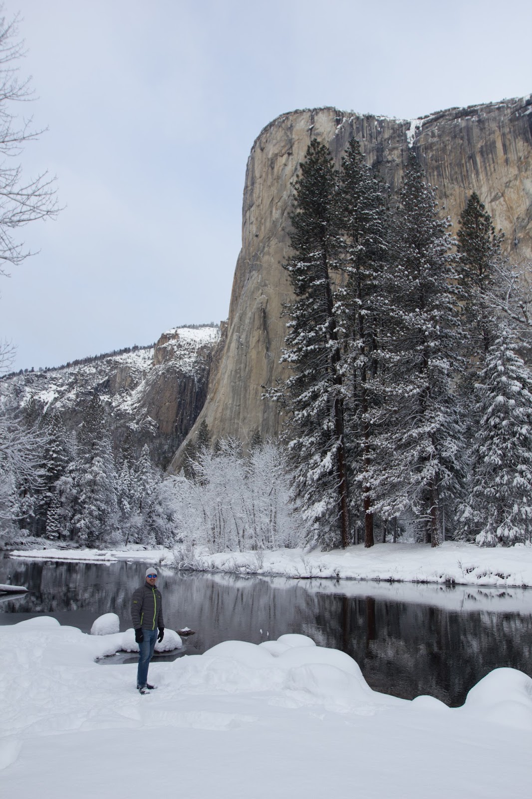
Steve in front of El Capitan, Yosemite NP.

Christmas morning we ate breakfast at the hotel, then drove to Yosemite, about 1 hour away. There was fresh snow in the park and it was spectacular!  We got to the park about 9:30 am and had to wait in a line a short time to get a space to put chains on the truck tires (mandatory in the park that day). It was COLD outside in the morning - maybe 15-20 - but very, very pretty.  It looked like Yosemite Valley had gotten ~12-15 inches of snow in the previous 24 hours, and it was still cold enough that it blanketed everything. As the day went on though, it started to melt off the trees a bit and it warmed up. We'd packed plenty of warm clothes though, and did some fun, short hikes and exploring in the snow. We even packed our lunch and stopped to make hot coffee for Steve.
Half dome (right), nearing sunset (above).


I've already forgotten which waterfall this is (below), dang it. It's behind Yosemite Lodge:
 
We stuck around the park after dark to try to see the full moon rise. It got really, really cold!  Steve sat in the truck, turning it on from time to time. I would jump in and out to warm up while waiting. This is a long exposure of Half Dome with the moon just about to rise on the left side:
Then this is a wider shot of the valley with the moon up and lighting things up:
I got really frustrated during this part of the day...it was dark out and really cold, but a ton of vehicles driving by. Just as a the moon was coming up, a park police officer pulled over a car in front of us, and he left his flashing lights on, which completely messed up any chance of getting good night shots of the moon!  Grrrr!

10 December 2015

Scenic flight from Anchorage

I was in Anchorage Sunday-Thursday for a work meeting. It was cold - about 8-12 degrees most days - but clear skies for the most part so the surrounding mountains were beautiful...not that I was outside much during daylight hours to see them.
Taxiing as the sun comes up.
The best part was the flight home since my plane took off right about sunrise (10 am!). The few clouds were lit up in pinks and oranges and the snow on the mountains was also turning pink and orange. A friend from Juneau was also unexpectedly on my flight, and was sitting in the seat behind mine! It was fun to catch up and since he's been in Alaska a really long time and is a tour guide, he was pointing out all the mountain, glacier, and town names as we flew over them.

Sea ice and a pink sky just as we're taking off.

Now heading southeast and over the Kenai Peninsula.

I've never flown over this part of the coast before (without clouds). In the lower left is Kruzof Island with Mt. Edgecumbe - a dormant volcano - and another collapsed cone next to it. You can sort of see the town of Sitka in the upper right, straight below the tip of the plane wing part. Sitka sits on Baranof Island. Behind Sitka on the other side of the mountains is a flat bank of clouds sitting over Chatham Strait, then beyond that is Admiralty Island, which you can see from Juneau!

The worst part of the flight was landing in Seattle. It was really windy and stormy so there was a decent amount of turbulence...and someone a few rows up barfed all over as we were landing. We had to stop on an offshoot of the tarmac while the flight attendants delivered things to clean up. Yuck, and a huge bummer for the rest of the people in the row.

05 December 2015

A working mill

On one of the motorcycle forums that Steve follows he found a photo of a really picturesque old mill about and hour and a half from our house called the Cedar Creek Grist Mill. So today on a whim we headed down to check it out (despite the rainy weather). It was fantastic!  It's only a couple of miles off the interstate, tucked in a little valley. 
The mill was originally build in 1876 but after the logging boom ended, it became a machine shop until it was abandoned in the the 1950s or so. Finally in the 1980s renovations started and brought it back to working condition as a mill. The only original components are the turbine and some parts of the wooden structure. In the past, a dam provided the water power, now due to concerns about salmon the water power comes a flume. 
The mill is now open on weekends and staff by a couple of volunteers who told us about the history and then cranked up the mill so we could watch them grind some soft wheat and some corn. The best part - you can take some home!  We now have samples of stone ground hard wheat flour (for bread), soft wheat flour (for pancakes, cookies, and biscuits), and corn meal! I'm all excited to cook with it, but I leave tomorrow morning for Anchorage. But when I come home, I am going to try to bake using the flours.


24 November 2015

South!

We went camping in northern California, to Redwood National Park. It was a beautiful, sunny, fun weekend getaway.  We got really lucky with the weather, it was nice every day until the drive home when it started raining around sunset in Oregon. The coast area gets a lot of fog, sometimes all days at the coast, sometimes only at night. At night it was such thick fog it would drip from the trees on our campsite. 

On the way down, we stopped at the Tillamook Cheese Factory, watched the staff process cheese for quite a while, sampled all their cheese, and bought some to bring home. I think I should have gone into some sort of food science field - combine my love of cooking and interest in science into a job. It was really fun to watch them work and try to figure out how everything worked.
We lucked out on this sunset - we were in the perfect place at just the right time.
The trees in the parks (there are several State and National parks in the area) were so huge, it was hard to wrap our heads around their size and age.
Beaches!

There are three herds of Roosevelt elk in the area and we saw all three. These were the northern-most herd., close to our campsite.
We also saw lots of birds, deer, a porcupine (really really close!) and an owl!

This is trillium falls. We went on a 3 mile loop hike through giant trees and tiny creeks.
Steve, enjoying some cheese and a sunny lunch spot.
And a little scenery on the drive home too. This is the Smith River, middle fork.


17 October 2015

A short hike in Rainier

I'm post-dating this - we went hiking last weekend before I left for a work trip to San Diego. About noon on Saturday we decided it was too nice out to stay indoors, so we shoved a few things into a backpack and headed up to Rainier. It was cloudier (and rainier) up the mountain, but we still did a short 3 mile hike to a couple of waterfalls then headed further up the mountain in the car to view another waterfall. By the time we headed home it was definitely raining instead of 'spritzing' (Steve's word).

To get to the trail we had to cross a loud, rushing glacier fed stream (thus the milky color).  There's no way we could have crossed this safely without the bridge. Thankfully, the bridge was very sturdy, but you could see the previous two bridges a bit further downstream, where they'd been washed in past flooding. The trail we hiked was a short section of the Wonderland trail, which is a huge loop circling the base of Mt. Rainier. 
The trail to the waterfall looked flat on the map, but in reality it was a pretty steep uphill hike for almost all of it. This is the second of the two waterfalls on the trail:
 This is the waterfall we took the car to see. It's only a short distance from the main road, and quite pretty. By this point it was raining pretty steadily so we didn't linger.